 EMODnet Product Catalogue
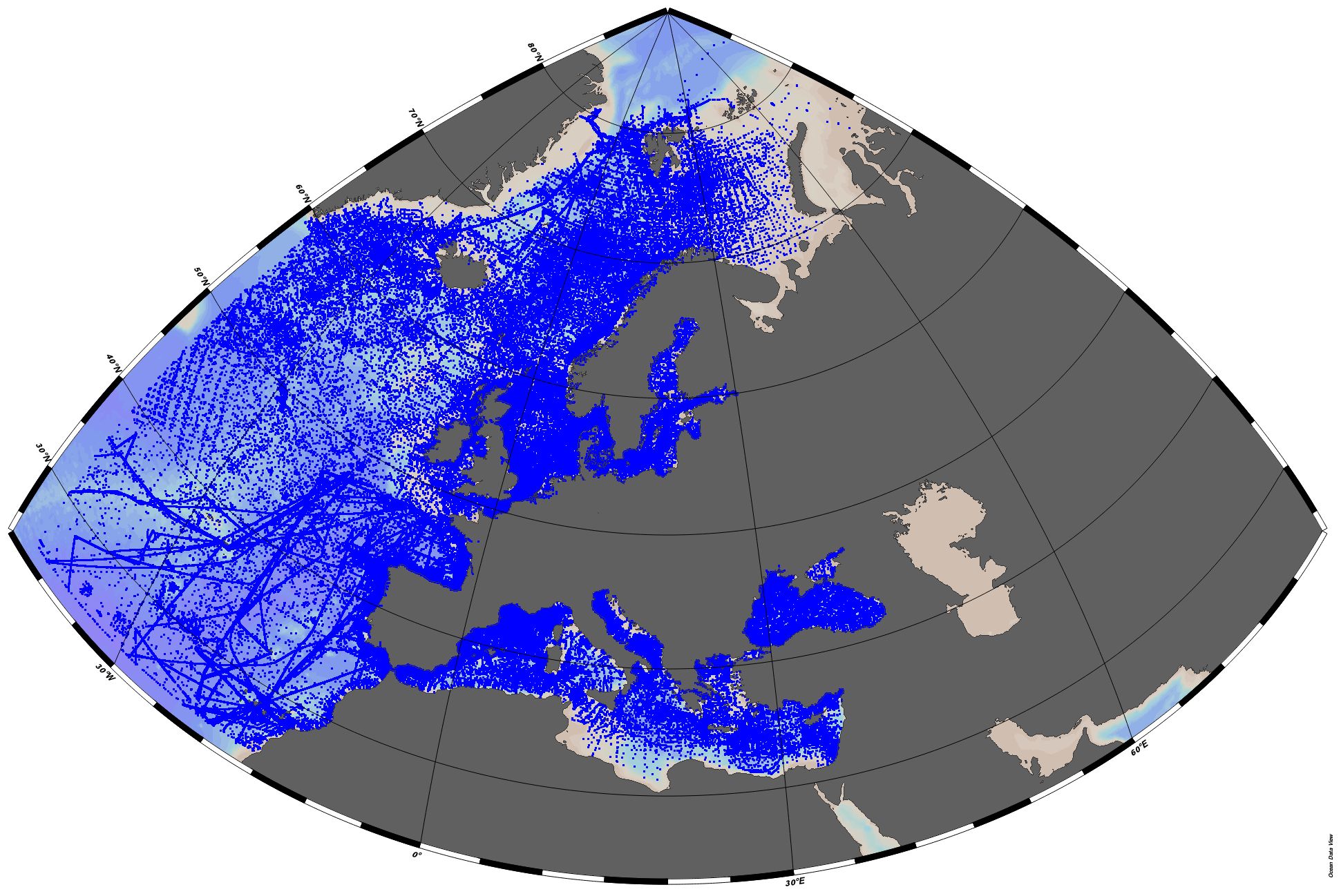
Northeast Atlantic Ocean (40W)
Type of resources
Available actions
Topics
Keywords
Contact for the resource
Provided by
Years
Formats
Representation types
Scale 1:
Resolution
-

EMODnet Chemistry aims to provide access to marine chemistry data sets and derived data products concerning eutrophication, ocean acidification and contaminants. The chemicals chosen reflect importance to the Marine Strategy Framework Directive (MSFD). This regional aggregated dataset contains all unrestricted EMODnet Chemistry data on contaminants (20 parameters), and covers the North East Atlantic Ocean with 2400 CDI records divided per matrices: 122 in biota (as time series), 1689 in water (as vertical profiles), 589 in sediment (478 Vertical profiles and 111 Time series). Vertical profiles temporal range is from 1970-07-29 to 2017-02-28. Time series temporal range is from 1979-02-28 to 2014-10-21. Data were aggregated and quality controlled by ‘IFREMER / IDM / SISMER - Scientific Information Systems for the SEA’ from France. Regional datasets concerning contaminants are automatically harvested. Parameter names in these datasets are based on P01, BODC Parameter Usage Vocabulary, which is available at: http://seadatanet.maris2.nl/bandit/browse_step.php . Each measurement value has a quality flag indicator. The resulting data collections for each Sea Basin are harmonised, and the collections are quality controlled by EMODnet Chemistry Regional Leaders using ODV Software and following a common methodology for all Sea Regions. Harmonisation means that: (1) unit conversion is carried out to express contaminant concentrations with a limited set of measurement units (according to EU directives 2013/39/UE; Comm. Dec. EU 2017/848) and (2) merging of variables described by different “local names” ,but corresponding exactly to the same concepts in BODC P01 vocabulary. The harmonised dataset can be downloaded as ODV spreadsheet (TXT file), which is composed of metadata header followed by tab separated values. This worksheet can be imported to ODV Software for visualisation (More information can be found at: https://www.seadatanet.org/Software/ODV ). The same dataset is offered also as XLSX file in a long/vertical format, in which each P01 measurement is a record line. Additionally, there are a series of columns that split P01 terms in subcomponents (measure, substance, CAS number, matrix...).This transposed format is more adapted to worksheet applications users (e.g. LibreOffice Calc). The 20 parameter names in this metadata record are based on P02, SeaDataNet Parameter Discovery Vocabulary, which is available at: http://seadatanet.maris2.nl/v_bodc_vocab_v2/vocab_relations.asp?lib=P02 . Detailed documentation will be published soon. The original datasets can be searched and downloaded from EMODnet Chemistry Download Service: https://emodnet-chemistry.maris.nl/search
-
In the framework of the Research Vessel JM Navaz (Spanish Institute of Oceanography, IEO) routine field and monitoring operations on the Galician coastal waters, a continuous thermosalinograph (TSG, SeaBird 21) with a fluorometer (Turner 10) was installed in 2007 as an IEO contribution to the RAIA observatory in Galicia-North Portugal (http://marnaraia.org). This research vessel has sampled the Galician Rias Baixas (Vigo, Pontevedra, Arousa and Muros) and the adjacent shelf in the framework of the IEO monitoring program RADIALES (monthly sampling, https://www.seriestemporales-ieo.net/) and also of the harmful algae Galician monitoring of INTECMAR (weekly sampling, http://www.intecmar.gal/). Data was routinely sent to the IEO datacenter and underway data are available from 12th December 2007 to 10th January 2017. During this period, the vessel performed more than 930 sampling cruises with underway TSG data, working around 6 900 hours and sailing close to 100 000 km. It has registered more than 800 000 temperature and salinity data and more than 450 000 fluorescence records. A recent revision, standardization and quality control/quality assessment of the dataset have been performed in the framework of SeaDataCloud (H2020 INFRARAIA-1-2016-2017, n730960) with additional support from MyCOAST (Interreg Atlantic Area EAPA 285/2016) and MarRISK (Interreg POCTEP Galicia-N Portugal, 0262_MARRISK_1_E) projects. This includes re-checking the clock, position, vessel speed, and recorded temperature, salinity and fluorometry values, as well as vocabularies that facilitate reuse of them. The whole dataset is provided with updated quality flags (QF) that improve their reusability. Weekly datafiles and the QF follow the seadatanet.org standards, as in formats as in vocabularies, in the pursuit of the FAIR (findable, accessible, interoperable, and reusable) data principles for sharing. At the moment, these data are freely distributed using OGC standard services (WMS, WFS, etc.) through institutional Thredds (http://centolo.co.ieo.es:8080/thredds/catalog/rv/Navaz/catalog.html) and Geoserver (http://centolo.co.ieo.es:8080/geoserver/web/) which facilitates the user's queries, automation of routines (e. g. model validation), and the development and implementation of web services and applications. Important Note: This submission has been initially submitted to SEA scieNtific Open data Edition (SEANOE) publication service and received the recorded DOI. The metadata elements have been further processed (refined) in EMODnet Ingestion Service in order to conform with the Data Submission Service specifications.
-
In the framework of the R/V J. Rioja (Spanish Institute of Oceanography, IEO-CSIC) routine field and monitoring operations on the Cantabrian Sea waters (southern Bay of Biscay), a continuous thermosalinometer (TSG, SeaBird 21) was installed in 2002 as an IEO contribution to the Ferrybox EU-funded project (2002-2005, EC-FP5-EESD nºEVK2-2002-00144). This research vessel has sampled the area in the framework of the IEO monitoring program RADIALES (monthly sampling, https://www.seriestemporales-ieo.net/). Data was routinely sent to the IEO datacenter and underway data are available from 15th October 2002 to 25th October 2012. During this period, the vessel performed more than 120 monthly sampling cruises with underway TSG data, recording more than 492 000 temperature and salinity lines. A recent revision, standardization and quality control/quality assessment of the dataset have been performed in the framework of SeaDataCloud project (H2020 INFRARAIA-1-2016-2017, n730960). This includes re-checking the clock, position, vessel speed, and recorded temperature and salinity values, as well as vocabularies that facilitate the accesibility of them. The whole dataset is provided with updated quality flags (QF) that improve their reusability. Monthly datafiles and the QF follow the seadatanet.org standards, as in formats as in vocabularies, in the pursuit of the FAIR (findable, accessible, interoperable, and reusable) data principles for sharing. At the moment, these data are freely distributed using OGC standard services (WMS, WFS, etc.) through institutional Thredds (http://centolo.co.ieo.es:8080/geoserver/web/) which facilitates the user's queries, automation of routines (e. g. model validation), and the development and implementation of web services and applications. Ref: Viloria, A. Atlas costero de temperatura y salinidad superficial en el Cantábrico. Master thesis. U Vigo (2012). http://hdl.handle.net/10508/15653 Important Note: This submission has been initially submitted to SEA scieNtific Open data Edition (SEANOE) publication service and received the recorded DOI. The metadata elements have been further processed (refined) in EMODnet Ingestion Service in order to conform with the Data Submission Service specifications.
-
EMODnet Chemistry aims to provide access to marine chemistry datasets and derived data products concerning eutrophication, acidity and contaminants. The importance of the selected substances and other parameters relates to the Marine Strategy Framework Directive (MSFD). This aggregated dataset contains all unrestricted EMODnet Chemistry data profiles on eutrophication and acidity, and covers: the Artic Ocean, the North East Atlantic, the Greater North Sea and Celtic Seas, the Baltic Sea, the Mediterranean Sea and the Black Sea. ITS-90 water temperature and water body salinity variables have also been included ('as are') to complete the eutrophication and acidity data. If you use these variables for calculations, please refer to SeaDataNet for the quality flags: https://www.seadatanet.org/Products/Aggregated-datasets. This European dataset is the result of the aggregation of the regional datasets concerning eutrophication and acidity present in EMODnet Chemistry. The regional datasets are automatically harvested, and the resulting collections are aggregated and quality controlled using ODV Software and following a common methodology for all sea regions ( https://doi.org/10.13120/8xm0-5m67). Parameter names are based on P35 vocabulary, which relates to EMODnet Chemistry aggregated parameter names and is available at: https://vocab.nerc.ac.uk/search_nvs/P35/. This process were regionally performed by: 'Institute of Marine Research - Norwegian Marine Data Centre (NMD)' (Norway), 'IFREMER / IDM / SISMER - Scientific Information Systems for the SEA' (France), 'Aarhus University, Department of Bioscience, Marine Ecology Roskilde' (Denmark), 'Swedish Meteorological and Hydrological Institute (SMHI)' (Sweden), 'Hellenic Centre for Marine Research, Hellenic National Oceanographic Data Centre (HCMR/HNODC)' (Greece) and 'National Institute for Marine Research and Development 'Grigore Antipa' (Romania). When not present in original data, water body nitrate plus nitrite was calculated by summing all nitrate and nitrite parameters. The same procedure was applied for water body dissolved inorganic nitrogen (DIN), which was calculated by summing all nitrate, nitrite, and ammonium parameters. Concentrations per unit mass were converted to a unit volume using a constant density of 1.25 kg/L. The aggregated dataset can be downloaded as an ODV collection.
-
This dataset gather isotopic ratios measured on 359 fish, sharks and crustaceans collected between 200 and 800 m depth, in the Mediterranean canyons during MEDITS 2012 and 2013 surveys Important Note: This submission has been initially submitted to SEA scieNtific Open data Edition (SEANOE) publication service and received the recorded DOI. The metadata elements have been further processed (refined) in EMODnet Ingestion Service in order to conform with the Data Submission Service specifications.
-
This dataset contains dissolved iron concentrations ((Fe(II) + Fe(III); µmol/l) acquired between July 2017 and March 2018 (n=168) using the CHEMINI Fe, a CHEmical MINIaturized analyser (samples taken every 12 hours, with daily in situ calibration using a 20 µmol/l iron standard, Vuillemin et al., 2009). The sample inlet was positioned on the mussel bed at the base of the Tour Eiffel edifice of the Lucky Strike hydrothermal vent (1695 depth).CHEMINI Fe (CF2) was mounted on the TEMPO module which was itself connected to the SeaMON East node of the EMSO-Azores observatory. Important Note: This submission has been initially submitted to SEA scieNtific Open data Edition (SEANOE) publication service and received the recorded DOI. The metadata elements have been further processed (refined) in EMODnet Ingestion Service in order to conform with the Data Submission Service specifications.
-
This dataset contains dissolved iron concentrations ((Fe(II) + Fe(III); µmol/l) acquired between September 2016 and February 2017 (n=332) using the CHEMINI Fe, a CHEmical MINIaturized analyser (samples taken every 24 hours, with daily in situ calibration using a 25 µmol/l iron standard, Vuillemin et al., 2009). The sample inlet was positioned on the mussel bed at the base of the Tour Eiffel edifice of the Lucky Strike hydrothermal vent (1695 depth).CHEMINI Fe (CF1) was mounted on the TEMPO module which was itself connected to the SeaMON East node of the EMSO-Azores observatory. Important Note: This submission has been initially submitted to SEA scieNtific Open data Edition (SEANOE) publication service and received the recorded DOI. The metadata elements have been further processed (refined) in EMODnet Ingestion Service in order to conform with the Data Submission Service specifications.
-
This dataset contains seafloor pressure data acquired in the framework of EMSO-Azores observatory between August 2018 and June 2019 using a SBE53 pressure gauges deployed on two sites. West site : The sensor was deployed on an existing benchmark installed with the submersible Nautile in August 2006 during the GRAVILUCK cruise (https://doi.org/10.17600/6010110). The benchmark sits on hard substratum with light hydrothermal sedimentation, on the North-West border of the Lucky Strike lava lake, next to a hydrothermal site. East site : The sensor was deployed on an existing benchmark installed by freefall in July 2007 during the MOMARDREAM cruise (https://doi.org/10.17600/7030060). The benchmark sits in the axial valley, East of the LuckyStrike volcano in a lightly sedimented area, with apparent pillow lavas. Instrument location bathymetric map Image Reference: https://www.seanoe.org/data/00654/76598/illustrations/illustration-96.gif. Important Note: This submission has been initially submitted to SEA scieNtific Open data Edition (SEANOE) publication service and received the recorded DOI. The metadata elements have been further processed (refined) in EMODnet Ingestion Service in order to conform with the Data Submission Service specifications.
-
This dataset contains seafloor pressure data acquired in the framework of EMSO-Azores observatory between September 2016 and July 2017 using a SBE53 pressure gauges deployed on two sites. West site : The sensor was deployed on an existing benchmark installed with the submersible Nautile in August 2006 during the GRAVILUCK cruise (https://doi.org/10.17600/6010110). The benchmark sits on hard substratum with light hydrothermal sedimentation, on the North-West border of the Lucky Strike lava lake, next to a hydrothermal site. East site : The sensor was deployed on an existing benchmark installed by freefall in July 2007 during the MOMARDREAM cruise (https://doi.org/10.17600/7030060). The benchmark sits in the axial valley, East of the LuckyStrike volcano in a lightly sedimented area, with apparent pillow lavas. Instrument location bathymetric map Image Reference: https://www.seanoe.org/data/00694/80587/illustrations/illustration-121.gif. Important Note: This submission has been initially submitted to SEA scieNtific Open data Edition (SEANOE) publication service and received the recorded DOI. The metadata elements have been further processed (refined) in EMODnet Ingestion Service in order to conform with the Data Submission Service specifications.
-
This dataset contains dissolved iron concentrations ((Fe(II) + Fe(III); µmol/l) acquired between July 2019 and Septembre 2020 (n=1620) using the CHEMINI Fe, a CHEmical MINIaturized analyser (samples taken every 24 hours, with weekly in situ calibration using a 25 µmol/l iron standard, (Vuillemin et al., 2009)-[https://doi.org/10.1016/j.dsr.2009.02.002]). The sample inlet was positioned on the mussel bed at the base of the Tour Eiffel edifice of the Lucky Strike hydrothermal vent (1695 depth). CHEMINI Fe (CF2) was mounted on the TEMPO module which was itself connected to the SeaMON East node of the EMSO-Azores observatory. Important Note: This submission has been initially submitted to SEA scieNtific Open data Edition (SEANOE) publication service and received the recorded DOI. The metadata elements have been further processed (refined) in EMODnet Ingestion Service in order to conform with the Data Submission Service specifications.